


la Colle du Rouet, le Trou de Gournié, l'Endre

bernir
User
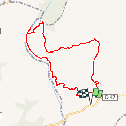

Length
10.8 km

Max alt
138 m

Uphill gradient
185 m
Km-Effort
13.3 km

Min alt
44 m

Downhill gradient
186 m
Boucle
Yes
Creation date :
2019-10-03 08:19:17.923
Updated on :
2019-10-09 22:42:10.191
5h20
Difficulty : Easy

FREE GPS app for hiking
 SityTrail
IGN / Geographical institutes
SityTrail Plus
The world is yours!
About
Trail Walking of 10.8 km to be discovered at Provence-Alpes-Côte d'Azur, Var, Le Muy. This trail is proposed by bernir.
Positioning
Country:
France
Region :
Provence-Alpes-Côte d'Azur
Department/Province :
Var
Municipality :
Le Muy
Location:
Unknown
Start:(Dec)
Start:(UTM)
305965 ; 4819992 (32T) N.
Comments